Riding Mountain National Park Vegetation Modelling
Riding Mountain National Park (RMNP) is located in the Boreal Plains of southern Manitoba, a region where grassland was historically maintained by frequent fires and grazing by bison that inhibited forest establishment. Suppression of fire and extirpation of bison have allowed forest to encroach on grassland, and maintenance of grassland is an important management priority for the park. The ALCES Flow landscape simulator was applied to explore fire and vegetation dynamics in the park in order to inform future management actions such as the use of prescribed fire. Simulations exposed grassland to encroachment using an algorithm that was informed by information in the literature on expected rates and spatial patterns of forest encroachment in aspen parkland ecosystems. Grassland was simulated to decline by 20 to 50% over a 10-year period in the absence of prescribed fire. Prescribed burning was effective at suppressing woody encroachment, but simulations indicated that a sustained effort will be required to reverse grassland decline. A wide range of prescribed fire and grazing strategies were simulated to inform the design of an efficient prescribed burning program. Prescribed forest fire was more efficient at suppressing woody encroachment than targeted burning of large grassland patches. This counter-intuitive outcome was due to ability of forest fire to burn small grassland patches that are dispersed through the forest matrix and that are otherwise susceptible to woody encroachment. Targeted burning is also needed to maintain large grassland patches, however, such that an effective prescribed burning program will require a combination of targeted grassland burns and prescribed forest fire. Another recommendation based on the simulations was that burning more patches less frequently is preferred to burning fewer patches more frequently, especially if grazing by bison is applied in the intervening years between burns to suppress woody encroachment.
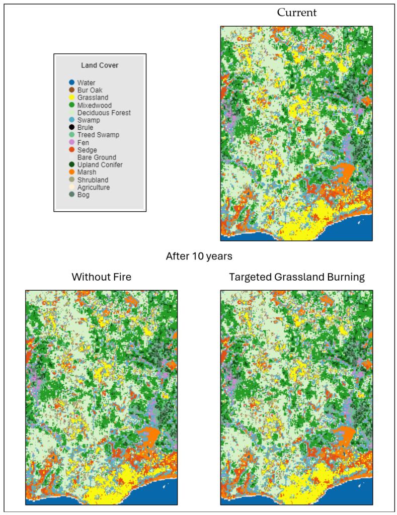
An example of land cover within Riding Mountain National Park at the start and end of simulations without prescribed grassland fire and with targeted burning of grassland patches. Grassland is in yellow. Prescribed fire was effective at suppressing woody encroachment of the large grassland patch at the bottom because it was large enough to be prioritized for burning. Prescribed fire was not effective at suppressing woody encroachment of the other patches in the maps which were not large enough to be selected for burning. The map focuses on a small portion of RMNP to show detail.